INTRODUCTION
Urban planning and related policies can contribute to improvement in health.1 Recent epidemiological and quantitative Health Impact Assessment (HIA) studies in high income countries suggest that a change from passive (car) to active transportation (cycling, walking) and public transport in daily life2,3,4,5 limit chronic disease, and reduce air pollution emissions, including greenhouse gasses, have been recommended. Transportation and planning policies that promote active travel by walking and cycling can contribute to these goals, potentially yielding further co-benefits. Little is known, however, about the interconnections among effects of policies considered, including potential unintended consequences.
OBJECTIVES AND METHODS
We review available literature regarding health impacts from policies that encourage active travel in the context of developing health impact assessment (HIA could improve health through mechanisms such as an increase in physical activity and social contacts and a reduction in stress and pollution levels.2 However, there is a large gap between urban planners and public health researchers, resulting in that new research findings are not implemented in urban policies. Amongst others, this may be because the tools for active transportation are fairly new and need to be further calibrated for new situations.6
The transport sector represents a significant contributor to greenhouse gases, heat islands, and noise and air pollution. The introduction of more efficient cars and reducing vehicular travel are essential components of climate change mitigation policies across the world. Shifting the population towards active modes of transportation (e.g. cycling, walking) represents a particularly promising strategy with a high potential of public health co-benefits. Such change may result in a sustained increase in physical activity in the population – a major requirement to abate the obesity epidemic. Other potential benefits include improvements in environmental quality indicators such as ambient air pollution and noise, as well as in the social environment (social capital) and quality of urban life, and related health impacts.2 However, depending on local conditions and policies, these strategies may also result in adverse health effects as inhalation of air pollutants may increase among those physically active along traffic arteries and traffic accident rates may increase.2
There are now holistic frameworks and related tools for policy makers available to evaluate the expected health impacts of active transportation in European cities.2,3,4,5,6 The conduct of such quantitative HIA relies on data availability and a large number of assumptions.7 Whereas in high income countries this data may be available, this may not be the case in low- and middle- income countries, where only one HIA has been conducted.8 Cities in low- and middle-income countries provide great opportunities to conduct quantitative HIA and implement the findings because of the rapid and often unplanned urban expansion, the limited transport planning and the health related consequences.9 Furthermore, in such countries levels of physical inactivity are rapidly increasing10 and traffic accidents represent an important health and economic burden.11 We are therefore evaluating if we could expand the work conducted in European countries to other large low- and middle-income countries with fast growing cities. We also aim to evaluate the health impact of new urban policies planned in these growing cities. Particularly, we performed a feasibility study in two cities of two countries of Africa and Latin-America, respectively, with a low Gross National Product (GNP) but with perspectives of rapid economic, demographic and urban growth. In this regard, the two selected cities, Maputo (Mozambique) and Cochabamba (Bolivia), which have been rapidly expanding in the last decades, are expected to continue their expansion in the coming years, facing important urban and transport challenges. Additionally, we selected these two countries and cities because of their political stability and because there are two well-developed health research platforms established which facilitated the contact with local stakeholders and the implementation of the study. In this paper, we aim to provide a framework and description of the current situation regarding urban planning and transport management in these two cities and the potentiality to conduct a quantitative HIA study in relation to changes in urban transport policies.
METHODS
The screening process was focused on identifying data sources, indicators, policy descriptions and stakeholder perspectives in each city. A special effort was made to identify input data to conduct a quantitative HIA of urban and transport planning. Data on urban and transport policies, sociodemographic characteristics of the population, transport records (modal share and modal use), traffic safety, air pollution levels, and mortality and morbidity rates were collected. In order to identify data sources and collect this information stakeholders of the respective cities were selected and interviewed, including politicians and technicians of the municipality and different governmental departments, non-governmental organizations (NGOs), foundations, international cooperation organisms, and local university researchers. Part of the information was also obtained from the National Institute of Statistics of the respective countries. Finally, in order to have a perception of the built environment and mobility in the studied cities, and in order to capture the reality described by the stakeholders, we also conducted field work by using the different modes of public transport (bus, taxi, bike, ferry, etc.) around the different neighbourhoods of both cities. The field work did not follow a well-structured methodology as we did not aim to collect formal data, which in principle should be available through other sources.
MAPUTO (MOZAMBIQUE)
Maputo city is the capital of Mozambique, a country in the southeastern coast of Africa. Together with two other cities (Matola and Boane) and a district (Marracuene), Maputo city belongs to the Great Maputo area, which in total has a population of 2.2 million inhabitants, expected to increase to 3.7 million by 2035.12 While Maputo city is the political and industrial center of Mozambique, residential and industrial development has spread to Marracuene, Boane and, especially, Matola. Maputo has a dualistic urban structure: a center that follows the classical European design (densified, with tall buildings and following a grid pattern) and the surroundings, which are expanding and are characterized by a low-densified structure, with low buildings and fewer services available. Furthermore, some services (e.g. education and health), are better provided in Greater Maputo, particularly in Maputo city, than in other districts of the country.13 This is one of the main causes of the increase of the number of inhabitants in the area, which has translated into a huge number of daily person trips (3.1 million) within the Great Maputo area but also from other surrounding areas to Great Maputo.12
Transport Systems in Maputo
Maputo city and its surroundings count on a public transport system that currently cannot absorb all commuters moving everyday within the city and from the outskirts to the city center. In the last few years Mozambique has started to import used cars, mainly from Japan, and the number of people using this private transport is increasing every year (in 2035 the number of cars is expected to increase 1.5 times compared to the number of cars in 201212), which causes severe traffic jams and worsens the mobility in the area. In the next sentences we briefly explain each existing transport system in Great Maputo.
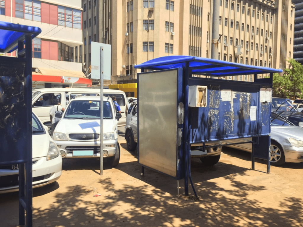
Bus system: Transporte Públicos de Maputo (TPM) is the state-owned company of bus service in Maputo. It owns around 350 buses but only 140 are operated daily in Greater Maputo as of 2013.12 Furthermore, according to TPM, since 2010 the number of bus passengers has decreased from 80.000 to 30.000, likely related with the loss in the quality of service (associated with the old buses and the poor maintenance) and a reduction in the service (associated with the traffic jams that reduce the number of trips per route and the bus speed) (Figure 1). It is, however, the cheapest transport system.
Figure 1: Cars on the sidewalk and infront of the bus stop in Maputo, Mozambique.
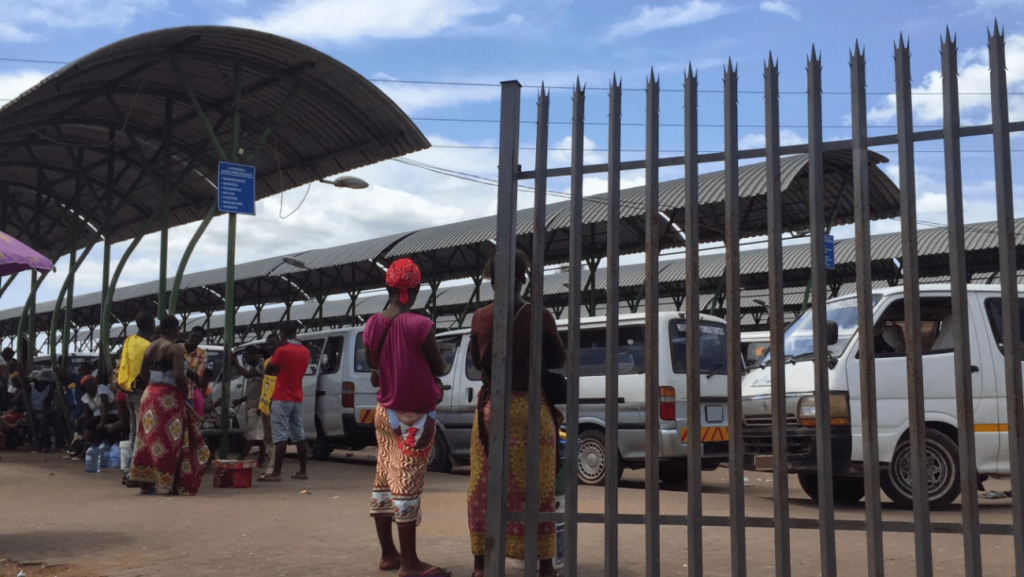
Mini bus system: Most commuters in Maputo use private mini-bus called “chapas 100” because they are faster than buses and reach certain parts of the city that buses do not. However, “chapas 100” are more expensive and operate following the “fill and go” system, which causes long queues of passengers in the terminals (Figure 2). Additionally, commuters can stop “chapas 100” anywhere along the route (no regulated stops exist), a system that worsens traffic jams and safety, especially at peak hours. A great part of “chapas 100” fleet is poorly maintained, and many are involved in road traffic accidents. Because of the high demand of transport in Great Maputo, since few years ago a new version of “chapas 100”, known as “my love”, is also circulating. These are pick-up trucks that work following the same system as “chapas 100”, but the insecurity for commuters is greater due to the design of the vehicle (without cabin to protect the passengers), which makes people hug each other to avoid falling from the truck.Taxis are also available but represent a very small percentage compared to “chapas 100” and “my loves”.
Figure 2: “Chapas 100” station in Maputo, Mozambique.
Train system: Train service in Maputo is very limited. Although the number of passengers has increased from 0.45 million in 2007 to 1.26 million in 2011 the number of trains circulating everyday has not increased, which causes overcrowding of the trains and increase in the risk of road traffic accidents. There are four lines, three of which have two trains in each direction circulating every day, covering between 69 and 88 kilometres respectively. The fourth line has four trains covering 20 kilometres and running every day in each direction.
Ferry: Ferry service connects Maputo and the district of Katembe, located at the other side of the bay. The service is schedule every ten minutes, although the timings are relative. This service reduces the number of cars circulating in the highway connecting the two areas, but is more expensive than the toll located in the highway.
Cars: As previously said, in the last years Mozambique has started to import mainly used cars (they are cheaper, but more polluting, noisy and unsafe than new cars). More and more people are choosing this transport option every year (manly because the public transport options are not competitive, efficient, safe and fast), causing severe traffic jams at peak hours. Additionally, there are few parking areas in the city and cars often park on the sidewalks.
Walking and cycling: Despite that between 2010 and 2011 the government gave credits to buy bicycles and motorbikes, the use of the bicycles is very limited, mainly because commuters feel that it is dangerous due to the number of cars circulating, and also because there are not infrastructures to ride and park the bike. Most of the time sidewalks in Maputo are wide, but these are in a bad condition, often with big holes and mostly occupied by cars (Figure 1); for people with physical disabilities the access is even more difficult.
The Government of Mozambique requested the Government of Japan for assistance in formulating a “Comprehensive Urban Transport MasterPlan for the Greater Maputo” with the aim to improve mobility in the city now and in the coming 20 years, when the number of daily person trips is expected to double.12 The master plan was published in 2014 and considers three scenarios. The first would continue with the same land use and mobility pattern, whereas the other two propose a new distribution of land uses (and services) and the introduction of a Bus Rapid Transit (BRT) system and a Light Railway Transit (LRT) system connecting Maputo and Matola, among others.12 However, this plan does not take into account the implementation of bike lanes and improvements of sidewalks, but the city council is planning, through other projects, to improve mobility of bikes and pedestrians.
Conducting HIA in Maputo
With the current information available (see Table 1), it is not possible to conduct a quantitative HIA in Maputo. Although information on the types of transport used is available12), data on traffic injuries and mortality data is poor. For instance, there are around 11 different mortality databases in the country, and one person can be registered in none or in several of these databases, which are impossible to combine. Furthermore, the number of deaths occurring at the hospitals is very low (12%). A study conducted by the World Health Organization (WHO) during the first semester of 2014 could only quantify deaths related to road traffic accidents based on dead people arriving at the Central Hospital of Maputo. However, many road traffic accident deaths are not registered because the family of the dead removes the body even before the ambulance or the police reach the point where the accident occurred. Information on traffic injuries (type of lesion, types of transport involved, age and sex of the injured person, etc) is even scarcer, though the Health Ministry of the Mozambican Government is starting a pilot project to collect this information. Finally, information on the levels of physical activity of the general population is neither available in the country. It is also interesting to highlight that although traffic is a major problem in the capital of Mozambique in terms of air quality, another important source of pollution is the household cooking system, as many people still use charcoal and wood as fuel. This is important to take into account if HIA is conducted in the future in the city of Maputo.
| Table 1: Data sources available in Maputo and Cochabamba to conduct quantitative health impact assessment. |
|
Maputo (Mozambique) |
Cochabamba (Bolivia) |
| Mobility plan |
Available but not yet implemented (sources: JICA and municipality) |
Currently under development (sources: Swiss contact, BID and municipality) |
| Sociodemographic characteristics (gender, age) |
Partially available (low quality) (sources: NIS) |
Available (sources: NIS) |
| Mortality data |
Data available is not appropriate (only ≈12% of the total deaths are registered) (sources: WHO, Ministry of Health) |
Data available for the metropolitan area of Cochabamba (sources: NIS) |
| Health outcomes data and traffic injuries |
There is currently a project to register better the number of accidents, injuries and the mortality rates (within and outside the hospital). No information on when this data will be available (sources: Ministry of Health) |
Data available for the metropolitan area of Cochabamba (sources: NIS) |
| Air pollution & noise |
Very limited information (sources: Universidad Eduardo Mondlane) |
Data available on air pollution (NO2, SO2, O3; CO, PM10) and noise exists (sources: municipality) |
| Modal share (commuting) |
Data available in the mobility plan (sources: JICA, TPM) |
Data will be available in the urban development and mobility plan (sources: BID) |
| Physical activity |
There is not information on general physical activity among the population |
We have information on physical activity for the whole country (sources: NIS) |
| NIS: National Institute of Statistics; JICA: Japan International Cooperation Agency; BID: BancoInteramericano de Desarollo; TPM: Transporte Público de Maputo; WHO: World Health Organization. |
COCHABAMBA (BOLIVIA)
Cochabamba is located in the valley of Cochabamba in the centre of Bolivia, at 2500 m above sea level, and is the fourth largest city in the country. In 2012, there were 918.000 inhabitants, but the whole metropolitan area, which also includes the cities of Sacaba, Tiquipaya, Colcapirhua, Quillacollo, Vinto y SipeSipe, had around 1.5 million inhabitants.14 In two decades the population has increased a 150%, which has lead to a rapid and unplanned urbanization process (following an horizontal expansion) that has carried serious social and environmental challenges in the whole metropolitan area, including problems related to air pollution and mobility.14 A recent diagnostic on the urban development of the metrolopolitan area of Cochabamba highlighted mobility as a critical issue to be solved by the authorities, with an unsustainable public transport system and an increasing process of motorization.14 Until now the metropolitan area did not have a comprehensive plan on urban mobility, neither statistics on traffic flows, mobility surveys, transport modal shares nor any other updated statistics on the sector.14 Currently, this plan is being elaborated and will be finished soon.
Transport Systems in Cochabamba
Public transport, together with walking, is the most used transport system in Cochabamba. However, the private transport (including motorcycles) has substantially increased in the last years, and in parallel, the quality of public transport continues to decline.14 In the next lines we briefly explain each existing transport system in Cochabamba.
Public transport: buses, mini-bus and taxis: Cochabamba does not have an integrated public transport system, partly because of the strength of a number of private transport unions that do not want to lose the control of their businesses. The regular bus lines (owned and managed by the local authority) have official stops along the route. However, mini-buses, also called “trufis” and “taxi-trufis” (taxi cars that follow a fixed route with multiple passengers in a trip) are the most common public transport system in Cochabamba. These “trufis” and “taxi-trifies” are owned by private entrepreneurs, and follow the “fill and go” system, without fixed public transport stops. Also, “trufis” commonly carry more people than what is allowed, increasing the insecurity of passengers. The number of “trufis” in Cochabamba is substantial (mainly because the government does not regulate the number of “trufis” licences), with at least 60 lines operating. Due to the system followed (“fill and go”) they are a major source of traffic jams in the city. Common taxis are also available in Cochabamba.
Cars: Bolivia has now a new law that regulates the import of old cars in order to fight air pollution, a serious problem in the country, and particularly in big cities like La Paz and Cochabamba. However, the motorized fleet has substantially increased in the last years.14 Every day the city runs into serious traffic jams, especially in the city centre, despite there is a norm that regulates the entry of cars according to the car license plate number. The low quality and safety of the public transport system is another factor that has promoted the increase of the use of cars in the city. Also, and as it is occurring in other developing countries, car ownership is a sign of belonging to a higher socioeconomic status, which increases the interest to have one’s own car.
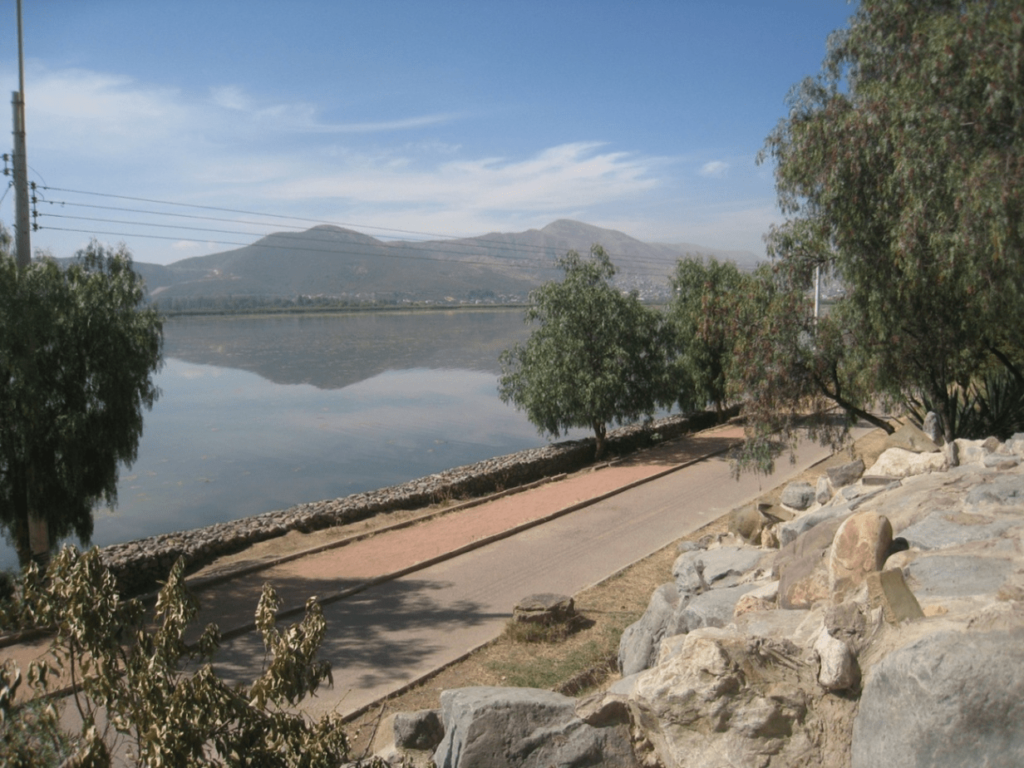
Walking and cycling: The city of Cochabamba has two bike lanes known as “ciclovías”. One of them is located in the north-east side of the city and surrounds Alalay lagoon (Figure 3). The other is small stretch located in the west part of the city. However, these bike lanes are mostly used as a recreative activity rather than as a useful infrastructure to move along the city. Moreover, the use of the bike as a common mode of transport has declined in the last years because of the nonexistent exclusive infrastructure and insecurity in the road (related to road traffic accidents and crime), despite optimal geographical and climatic conditions for its use.
Figure 3:“Ciclovía” (bikelane) in Cochabamba, Bolivia.
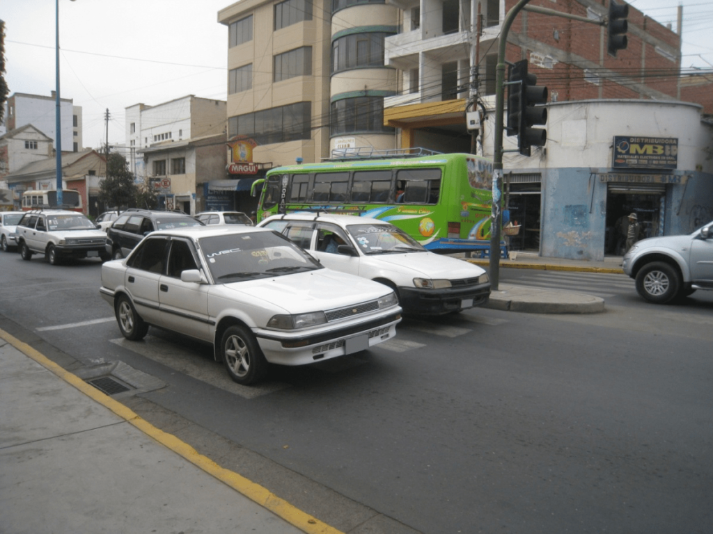
Sidewalks in Cochabamba are in a reasonable condition; cars do not generally park on them and they are clean and clearly identified. Although in specific spots these are adapted for disabled people, most of them need to be revised in order to facilitate their use. Additionally, there are very few pedestrian streets in the city. Despite the reasonable condition of the sidewalks in Cochabamba, most car drivers do not respect crosswalks and pedestrians have important problems to cross-busy streets (Figure 4).
Figure 4: Cars on a crosswalk while the traffic light indicates cars to stop.
Both the municipality of Cochabamba and the metropolitan area are currently developing their respective mobility plans, which are supposed to be finished by the end of 2015. The initiative “Ciudadesemergentes y sostenibles” (Emerging and sustainable cities) has already provided some guidelines expected to be followed by these plans in relation to mobility but also to urban planning: potentiate a more compact city and mix-use of land, urban distribution of goods in accordance with urban planning strategies, road traffic and parking control measures for the use of private vehicles, optimization of investments for expansion and maintenance of the road network, the support to pedestrians and the use of bike, creation of an integrated public transport system, etc.14
Conducting HIA in Cochabamba
With the current information available (see Table 1) it should be possible to conduct a HIA in Cochabamba as soon the mobility plan will be available. Data on traffic injuries and mortality data is available, and from this primary information other data needed to conduct quantitative HIA can be derived. Information on the levels of physical activity of the general population is available ata country level, obtained through health surveys conducted by the government. Cochabamba has one of the oldest air quality surveillance networks in Latin America (started in 2001), with continuous air quality records, which provided the information needed to conduct HIA in relation to air pollutants exposure.15
DISCUSSION
In both Maputo and Cochabamba a rapid population growth with poor urban and transport planning has resulted in a decline in public transport and in a rapid increase in private cars, with limited possibilities for walking and cycling. Minibus system is providing most of the mobility services in these cities. Both cities are also following the developments that has been seen in many rapid expanding cities in low- and middle-income countries.9 The current situation is likely to result in a large burden of disease, based on epidemiologic and HIA studies conducted in high income countries.2,3,4,5
Data to Conduct HIA
The rapid expansion of cities in low- and middle-income countries provides a unique opportunity for quantitative HIA researchers but also for other stakeholders interested in urban and transport planning (Table 2). However, to conduct quantitative HIA studies several data from different data sources is needed, and these are generally lacking in such countries. Although the feasibility of conducting HIA in low- and middle-income countries will depend on each specific country and city, a greater effort is needed to routinely collect basic demographic (e.g. population size, sex, age, births, deaths, socio-economic status) and health (e.g. diseases and death causes) data, as well as information on environmental exposures (e.g. air pollution) and on transport (e.g. modal use) to be able to make informed decisions in many fields (public health, urban design, mobility, etc). Also, exposure-response functions (e.g. for physical activity, air pollution) available in high income countries may not be appropriate for low- and middle-income countries. Therefore, epidemiological evidence is needed for these countries, as the current knowledge base is often poor or non-existent.
| Table 2: Opportunities and difficulties for research on Health impact assessment (HIA) of urban and transport planning in low- and middle-income countries. |
|
Opportunities |
Difficulties |
| Interventions and policies |
Fast urban growing of the cities and low development; possibilities for policy and intervention assessment; intersectorial approaches; establishment of new communication pathways between local authorities. |
Low regulations; low continuity in the policies; low cooperation between metropolitan authorities, departments (transport, health, environment, etc) and entities (NGOs, researchers, urban planners, etc). |
| Stakeholders |
New area of work and interest on the topic; identification of local necessities and key stakeholders; improvement of communication pathways and collaboration networks between interdisciplinary areas and regions. |
Low continuity in the work place; poor long-term stakeholder engagement; low understanding of HIA research |
| Data sources |
To design new indicators and new tools for data collection; to identify and implement basic data sources and tools for transport, urbanism, health and environment. |
Low capacity to collect routinely data; low comparability between data collected. |
| *These opportunities and difficulties are also useful for other stakeholders interested in urban and transport planning development, not only for HIA researchers. |
Urban and Transport Planning and Health in Developing Countries
Further studies are needed to evaluate the burden of disease related to future transport scenarios in cities from low- and middle-income countries.5,8 However, implication of policy makers to introduce the health perspective and HIA results in urban and transport decision making processes should be reinforced. Also, urban and transport policies should be addressed from a global perspective (i.e. metropolitan area), and not only at a municipality level, and should have continuity in order to have a real impact on people’s quality of life. In low- and middle income countries these policies are usually supported from NGOs, international cooperation agencies and foundations, which should be able to identify the necessities of the city, policy makers, local authorities and population, and to help with technical support, more than monetary assistance, to provide recommendations and interventions. Although it is not the aim of the present study to provide recommendations of implementations that cities from low- and middle-income countries should conduct, we here provide a few general actions that, according to previous experiences in high-income countries16 and according to mobility plans conducted in some of these cities12 could help to achieve the aims of having efficient and cost effective transport systems to stimulate economic development and innovation while producing the lowest burden on health (Table 3) and preventing the dependency from motorized vehicles.17 These interventions, which should be contemplated in urban and mobility plans in order to have them all integrated and well-coordinated, include, from the urban point of view, the promotion of mixed-land use (including a higher number of green and open public spaces) and high-density development with decentralized populations and services. From the mobility point of view, public transport needs to be reorganized and well-regulated in order to improve the service and the mobility itself. Also, the development of mass transit systems, such Bus Rapid Transit (BRT), would improve the service and reduce the number of private cars (in the case of Maputo, for instance, the existing train lines are an opportunity to provide a good service from the outskirts of the city towards its different areas). Improving sidewalks and increasing the number of areas exclusive for pedestrians are also important actions that need to be implemented, as well as a good regulation of parking areas in order to avoid cars on sidewalks and to facilitate the creation of car-free areas, as well as mobility itself. The promotion of bike use, with i.e. safe bike-lanes, is also a key aspect, as it is a cheap and sustainable mode of transport, and it is an interesting option for those with fewer economic resources.
| Table 3: Possible health effects of transport modes. |
|
Negative Effects |
Positive Effects |
| Public transport |
Low quality and unregulated public transport can increase the number of traffic injuries. |
Reduction of air and noise pollution; reduction of road traffic injuries (if it is well regulated and the quality of the service is good); increase of physical activity levels. |
| Cars and motorbikes |
Increase of air and noise pollution; increase of road traffic injuries; reduction of physical activity levels. |
|
| Walking and cycling |
Low quality infrastructures and regulations can increase road traffic injuries. |
Increase of physical activity levels; reduction of air and noise pollution. |
CONCLUSION
In low- and middle-income countries the pace of urbanization is fastest than in other regions of the world. Introducing the health perspective in urban and transport planning in these countries offers an opportunity to work towards the design of more sustainable and healthy cities. The current paper describes two examples of the opportunities and difficulties to conduct quantitative HIA in low- and middle-income countries, highlighting the limited availability of data (quantitatively and qualitatively) on transport and urban planning and health outcomes.
ACKNOWLEDGMENTS
This project was funded by the CERCA Institutes Integration Program (SUMA 2013) [promoted and managed by the Secretariat for Universities and Research of the Ministry Economy and Knowledge of the Government of Catalonia (SUR), the Agency for Management of University and Research Grants (AGAUR) and the CERCA Institute]. The funders had no role in study design, data collection and analysis, decision to publish, or preparation of the manuscript. We would like to thank to all the stakeholders and organizations willing to collaborate and provide information.
AUTHOR’S CONTRIBUTIONS
M.N, A.P. and M.G conceived and designed the study; M.N.M, S.T. and F.T. contributed obtaining the data; D.R.R. and M.G. analyzed the data; M.G. wrote the paper, with the collaboration of all authors, especially of D.R.R.
CONFLICTS OF INTEREST DECLARATION
The authors declare no competing financial interest.


